

© 2026 All Rights Reserved. 粤ICP备14051456号
2021-04-28
View:9
Recently, Chair Professor Junguo Liu’s research group from the School of Environmental Sciences & Engineering at the Southern University of Science and Technology (SUSTech), in collaboration with scholars from the University of Hong Kong (HKU) and Michigan State University, published findings for a new method that is used to extract high-resolution drainage network. The paper, entitled “Basin-scale high-resolution extraction of drainage networks using 10-m Sentinel-2 imagery” was published in Remote Sensing of Environment, a renowned academic journal that focuses on remote sensing studies.
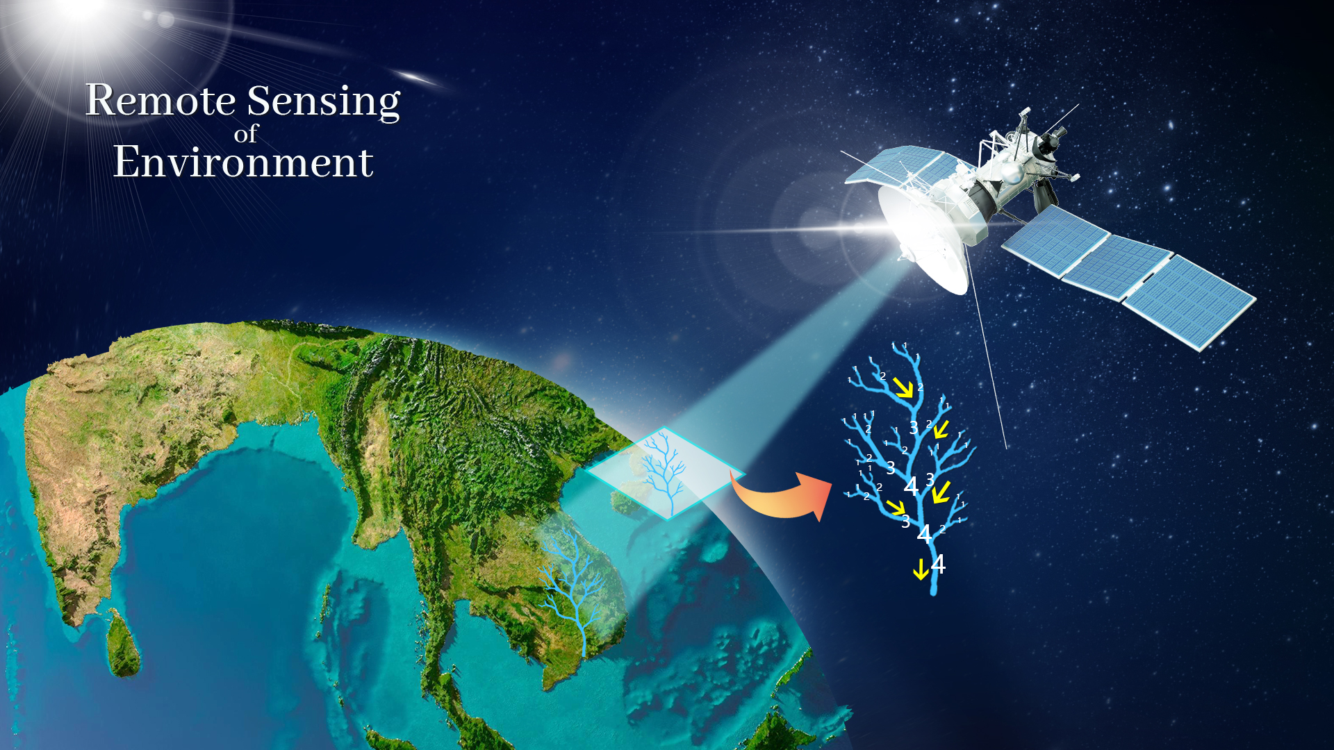
Extraction of drainage networks is an important element of river flow routing in hydrology and large-scale estimates of river behaviors in Earth sciences. Emerging studies with a focus on greenhouse gases reveal that small rivers can contribute to more than half of the global carbon emissions from inland waters (including lakes and wetlands). However, large-scale extraction of drainage networks is constrained by the coarse resolution of observational data and models, which hinders assessments of terrestrial hydrological and biogeochemical cycles.
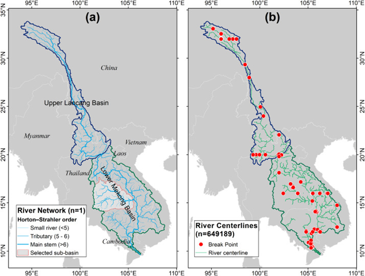
Figure 1: (a) Lancang-Mekong River networks extracted in this study. (b) State-of-the-art Landsat-based river centerlines extraction (GRWL) in the study area with breakpoints (river centerline disconnections).
Recognizing that the Sentinel-2 satellite can detect surface water up to a 10-m resolution over large scales, they proposed a new method named Remote Sensing Stream Burning (RSSB) to integrate high-resolution observational flow location with coarse topography to improve the extraction of the drainage network. In RSSB, satellite-derived input is integrated in a spatially continuous manner, producing a quasi-bathymetry map where relative relief is enforced, enabling a fine-grained, accurate, and multitemporal extraction of the drainage network. RSSB was applied to the Lancang-Mekong River basin to derive a 10-m resolution drainage network, with a significant reduction in location errors as validated by the river centerline measurements.
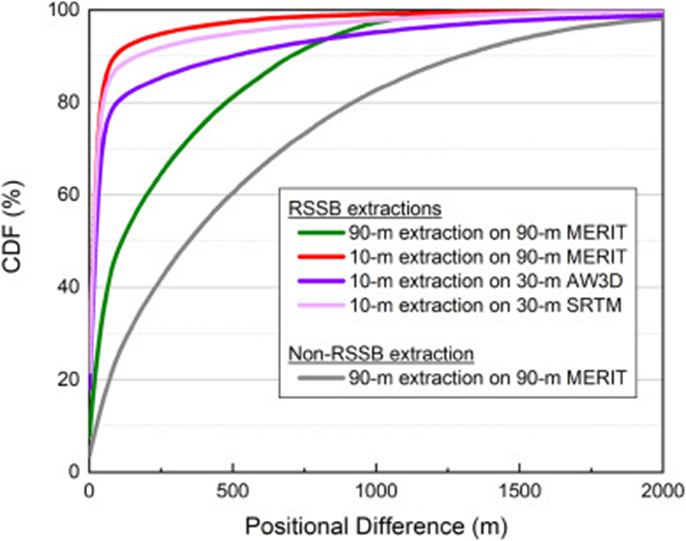
Figure 2: Location errors of river networks generated by the RSSB method and conventional method (non-RSSB). The closer the CDF curve near the top left, the better.
The high-resolution extraction resulted in a realistic representation of meanders and detailed network connections. Furthermore, RSSB enabled a multitemporal extraction of river networks during wet/dry seasons and before/after the formation of new channels. The proposed method is fully automated, meaning that the network extraction preserves basin-wide connectivity without requiring any postprocessing, hence facilitating the construction of drainage network data with openly accessible imagery.
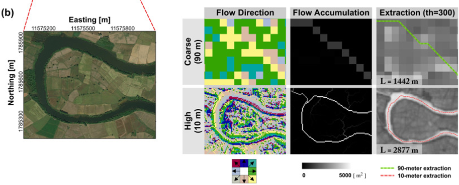
Figure 3: Comparisons of 90-m and 10-m drainage networks, including flow direction, flow accumulation, and extracted river vector.
The RSSB method provides a basis for the accurate representation of drainage networks that maintains channel connectivity, allowing a more realistic inclusion of small rivers and streams. This enables a greater understanding of complex but active exchange between inland water and other related Earth system components.
Zifeng Wang, a doctoral student supported by the joint Ph.D. program between SUSTech and HKU, and Junguo Liu, Chair Professor at SUSTech, are the first and corresponding authors, respectively, of this paper. Jinbao Li and Hongsheng Zhang from HKU, Ying Meng from SUSTech, and Yadu Pokhrel from Michigan State University are the co-authors.
This study was supported by the Strategic Priority Research Program of the Chinese Academy of Sciences, the National Natural Science Foundation of China (NSFC), and SUSTech.
Paper link: https://doi.org/10.1016/j.rse.2020.112281
2026-03-10
2026-09-08
A delegation of 13 students from Southern University of Science and Technology (SUSTech), Zhejiang University and the University of Science and Technology of China (USTC), accompanied by four SUSTech faculty members including including two affiliated with the State Key Laboratory of Soil Pollution Control and Safety, concluded a 12-day summer school at Flinders University in August, 2026, hosted by the University’s National Centre for Groundwater Research and Training (NCGRT).Throughout the program, the students participated in a wide range of educational activities covering water resources, environmental health, groundwater modeling, managed aquifer recharge, salinity management, mining sites management, virtual reality hydrology, and nature-based solutions for surface water, groundwater and soil pollution.A highlight of the visit was a series of field trips showcasing South Australia’s unique natural environments. These included an overnight excursion to a global showcase of integrated surface and groundwater management exemplified by the Murray-Darling Basin. Visits to the St Kilda Mangroves highlighted ecohydrological approaches to coastal mangrove conservation. While Hallett Cove featured the most famous glacial striation on pre-Cambrian rocks. Happy Valley Reservoir, Oaklands Wetland, and Port Willunga Beach, with their wildlife, water management and well-exposed sedimentary rock formations, left strong impressions on our students. Students also attended research seminars and explored Flinders University’s teaching and research facilities.This summer school provided an excellent opportunity for students to engage with Flinders University staff, students, and researchers, experience Australian approaches to soil and groundwater pollution control and safety research, and strengthen the institutional ties between SUSTech and Flinders University, while fostering international connections and cross-cultural learning. The visit was made possible through a combination of support provided by SUSTech and the Fundamental and Interdisciplinary Disciplines Breakthrough Plan of the Ministry of Education of China(JYB2025XDXM909).During the visit, Chair Professor Yan ZHENG from SUSTech delivered a research seminar on arsenic detection in the developed and developing world. Flinders University noted that its academic community was privileged to learn from her expertise.SUSTech expresses its gratitude for the incredible partnership with Flinders University at the conclusion of the program.
2026-04-22
On April 22, the Frontiers Planet Prize announced its list of 25 National Champions for 2026. Hong WANG, a 2025 graduate of the School of Environmental Science and Engineering at the Southern Universi
2026-04-20
On the morning of April 17, 2026, a delegation from Flinders University (Australia), led by Professor Colin Stirling, President of Flinders University, visited the Southern University of Science and T
2026-04-08
Hydrological models are foundational tools for water resource management, agricultural planning, flood and drought mitigation, and ecosystem protection. A long-standing challenge in hydrology is devel
 |